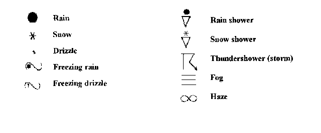
 Weather Symbols
A meteorogram is a graphical means of simultaneously displaying the time variations of several weather elements observed at a particular location. Traditionally, the term meteorogram is used to describe the time section or multiple plots of data taken from surface reporting stations. Meteorograms will be especially useful when we inspect and interpret the weather sequences associated with frontal passages.
The nature of the various weather elements requires that the meteorogram be capable of displaying these data in either numerical or symbolic form. One can assume that such elements as the air temperature , dewpoint temperature and barometric pressureare continuous in time and that the trend of each does not change greatly from one observation to the next. Hence, a numeric display can be made with lines drawn connecting these data points for a common weather element to form an approximate continuous time series of that weather element. Several other quantities such as cloud cover, and wind data (direction and speed) are better represented by discrete symbols centered upon the observation time.
For simplicity, the meteorogram is divided into five sections, each of which is used for plotting a different weather element, yet all have a common horizontal time scale. In each section, the vertical axis is scaled according to the range in the variation of the particular weather element.
The horizontal axis of the meteorogram represents time, increasing to the right on the graph. Hence, the appropriate information for each section of the meteorogram can be plotted at any selected time interval, usually every hour. Since the units for this scale usually are plotted in UTC or Z time , you will have to convert to local standard time.
TEMPERATURE & DEWPOINT
The top section of the meteorogram is designed to display the air temperature and dewpoint variations over the interval. This base grid is equivalent to an x-y graph. The exact vertical scale depends upon the range between the highest air temperature and the lowest dewpoint observed during the selected interval.
The air temperature and dewpoint temperature are assumed to vary continuously over time and that the trend of each does not change greatly from one observation to the next. Lines can be drawn connecting these data points to form a continuous thermograph for the temperature and a similar continuous time sequence for the dewpoint. A solid black line shows the temperature time trace and a thinner or dashed line depicts the trace of dewpoint temperature. Note that the temperature and dewpoint traces do not cross, since dewpoint usually never exceeds the air temperature.
Values of the daily maximum and minimum temperatures may be plotted below the chart at specific reporting times. The minimum temperatures are typically reported at 1200 and 1800 UTC, while the maximum temperatures are provided at 0000 and 0600 UTC.
WEATHER
The weather symbol entries appearing to the right of the title "WX" show the current significant weather phenomena or obstructions to visibility being reported at that time. These weather symbols correspond to the official station model code of symbols.
SNOW COVER
The numeric entries that may appear to the right of the title "SNOW" represent the reported depth of the snow cover in inches.
ACCUMULATED PRECIPITATION
The numeric entries that may appear to the right of the title "PREC" display the precipitation totals in inches. The values are 24 hour totals, generally reported at 1200 UTC, 6 hour totals made at 0000 UTC, 0600 and 1800 UTC, and 3 hour totals at the intermediate times.
An alternative method would be to plot a precipitation graph near the bottom of the meteorogram. This graph would be used to show the accumulation of precipitation with time. The data are plotted at each time the 3 or 6 hourly precipitation total is reported. A line would connect each plotted point.
VISIBILITY
The numeric entries appearing to the right of the title "VIS" indicate the horizontal visibility in statute miles.
WIND GUSTS
The numeric entries that may appear to the right of the title "GUSTS" represent wind gusts in knots, reported if the winds are strong and gusty. This entry is generally the maximum wind reported over a ten minute period during the observation of data.
WINDS & SKY COVER
The symbolic entries to the right of the "WINDS" title represent an abbreviated station model schematic containing the standard wind and cloud cover symbols used in the surface data plots (See Weather Symbol Legend).
The wind direction and speed information for a location are displayed symbolically by the traditional wind arrow arrangement. A shaft is oriented with the wind direction, oriented such that the wind barbs will be on the end of the shaft toward the direction from which the wind is blowing. (Up is north.) The wind direction is plotted to the nearest 10 degrees. Wind speeds are plotted with a series of wind barbs, to the nearest 5 knots using the code:
The wind information will be assumed to be discrete observations. No attempt is made to connect these observations to form a continuous time trace of wind speed.
The total cloud cover is plotted in symbolic form within the station model, according to the convention.
CLOUD CHART
This chart gives cloud layer information. The vertical axis portrays the height of the cloud base in feet and is logarithmic. All cloud layers are plotted as horizontal lines at the levels reported. Clear skies are plotted as a 'C'. Scattered cloud layers (1/8th to 3/8th coverage) are plotted as a single short dash. Broken cloud layers (4/8th to 7/8th coverage) are plotted as two short dashes. Overcast layers are plotted as a single long dash. The actual cloud ceiling is displayed below the chart in hundreds of feet if the ceiling were below 10,000 feet.
An alternate method for displaying the cloud information would entail a plot in a portion of the meteorogram designed for three cloud levels. The sequence of the sky cover and cloud height observations would be plotted in a simplified symbolic station model form. The abbreviations for the three rows of circles indicate, with the appropriate cloud base heights:
H             High              20,000 ft or higher
M            Middle            6500 ft to 20,000 ft
L             Low               6500 ft or lower
At each observation time, enter the cloud amount symbol in the appropriate cloud height for each reported sky condition (SCT, BKN, OVC or X). Nothing would be plotted for those times reporting CLR conditions.
AIR PRESSURE
Sea level corrected air pressure variations would be plotted in the lowest section of the meteorogram; the altimeter setting could be plotted instead, if pressure were not reported. The units of pressure are in millibars.
The barometric pressure trace is also assumed to be continuous with time, with a solid line connecting the plotted points to form a barogram.
Take time to study the variations of each weather element separately, and then in conjunction with the other displayed weather elements. Try to explain why these variations took place. With experience, you should be able to notice that various clues can be detected which help in your explanation.
If a 24 hour interval were plotted, a diurnal variation in the elements may be apparent. Usually, the temperature trace will show a distinct diurnal cycle. To help you visualize this diurnal variation, you may want to find the times of sunrise and sunset. However, complications such as clouds, the direction and speed of the wind, may influence the timing of the diurnal temperature cycle or completely obliterate it. For example, a low cloud layer may elevate the nighttime temperature and suppress the daytime temperature. Strong winds may be responsible for transporting warm or cold air into the region, causing a modification of the anticipated diurnal temperature curve. Frontal passages may cause rapid changes in several of the weather elements over short time intervals. Sequences of weather elements associated with cold frontal passages often differ from those associated with warm frontal passages.
Last revision 10 June 1996
© Copyright, 1996 Edward J. Hopkins, Ph.D. hopkins@meteor.wisc.eduMaster Links Page / Current Weather Page /ATM OCN 100 Home Page /AOS Dept. Home Page
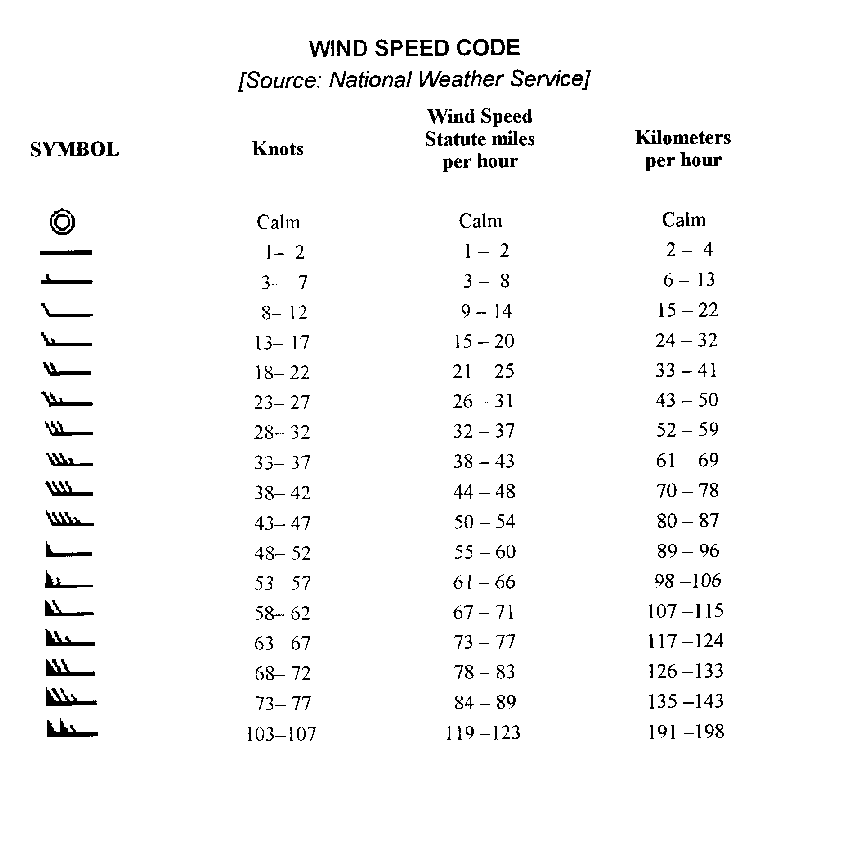 Wind speed code
 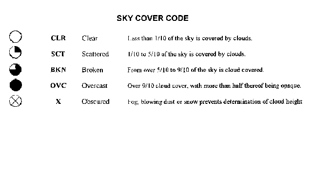 Sky cover code