Weekly Ocean News
27 November-1
December 2017
Items of Interest:
- December full moon is a "supermoon" -- The moon will pass through the full moon phase Sunday morning (officially, 1547Z on 3 December 2017, or 10:47 AM EST, 9:47 PM CST, etc.).
This full moon will occur approximately 16 hours before perigee, when the moon is closest to Earth in its elliptical orbit. Since the moon will come within 221,646 miles of Earth, it is called a "supermoon," as its closeness would make the moon appear larger than usual. [EarthSky]
The closeness of the moon and increased gravitational pull will cause an increase in the height of ocean tides, resulting in what is called a "perigean spring tide" (or King Tide) today and over the next day or two.
[NOAA National Ocean Service]
- NOAA Tide Tables for 2018 are available -- NOAA's National Ocean Service has announced that the 2018 NOAA Tide Tables and Tidal Current Tables are now available. These annual tide predictions and tidal current predictions, which represent the 152nd edition, can be obtained online for US coastal stations; printed tide tables are also available.
[NOAA National Ocean Service News]
Two years ago, a narrative along with a timeline visualization of the evolution of the NOAA Tide Tables since the first tide tables for locations along the East Coast of the United States when first published by the US Coast Survey in 1853. The changes in the methods used to compute the tide tables over the last 150 years are also described. [NOAA National Ocean Service News]
- Beginning of meteorological winter season -- The winter meteorological season
in the Northern Hemisphere starts on Friday (1 December). Recall that
climatologists and meteorologists have elected to use a standard three-month grouping to
identify each meteorological season. Hence,
the months of December, January and February are considered the winter meteorological season. You
will note that the winter solstice, marking the day where the length of
daylight is least in the Northern Hemisphere is still three weeks away,
falling on Thursday, 21 December 2017. Since the lowest temperatures
typically fall in mid to late January, the meteorological winter tends
to be centered on the coldest time of the year in the Northern
Hemisphere.
In addition, Thursday (30 November) marks the end of the official 2017
hurricane seasons in the North Atlantic, which includes the Gulf of
Mexico and the Caribbean, along with the eastern and central North
Pacific basins.
- The 2017 hurricane seasons reviewed -- With the end of the official 2017 hurricane season in
both the North Atlantic and North Pacific on Thursday (30 November 2017),
a quick review of this year's tropical cyclone statistics for the
official 2017 hurricane season has been made for both basins. [AMS
DataStreme Atmosphere]
For those who are interested in obtaining historic hurricane
information, the "Historical
Hurricanes Mapping & Analysis Tool" developed by NOAA
allows the search and display of detailed data for more than 6000
tropical cyclones in seven of the planet's major ocean basins based
upon a data set that runs from 1842 to 2016. Coastal population trends
are also available for the Atlantic and Gulf Coasts of the United
States.
- Tropical cyclone climatologies of North Atlantic
and the eastern North Pacific -- The National Hurricane
Center (NHC) has an updated and revised edition of its "Tropical
Cyclones of the North Atlantic Ocean, 1851-2006." While a paper copy of
this book is available for a cost from NHC, a 243-pg pdf file of this edition can be downloaded for free. NHC also released the first edition of
"Tropical Cyclones of the Eastern North Pacific Ocean, 1949-2006." In
addition to a paper copy is available for sale, a free 164-page pdf
file is available.
Both of these climatologies have numerous graphics that show long-term
changes in tropical cyclone frequency in the two basins.
A climatology of tropical cyclones in the central North Pacific from
the 1950s to 2013 is available from the CPHC
climatology website maintained by the Central Pacific
Hurricane Center (CPHC) in Honolulu, HI.
- It's Sure Dark! -- Have you noticed
that the sun is setting early these days? During the first ten days of
December, many locations throughout the country will experience their
earliest sunset times of the year. The exact day for the earliest
sunset depends upon the latitude, so you may want to check the date in
your locale from the sunrise tables appearing in an on-line,
interactive service available for the entire
year at most cities in the United States. The reason for the
earliest sunsets occurring in early December rather than on the winter
solstice (during the early morning hours of Wednesday, 21 December 2016) is
that the sun is not as precise a timekeeper as our watches. Because of
a combination of factors involved with Earth's elliptical orbit about
the sun and the tilt of Earth's spin axis with respect to the plane of
the ecliptic, the sun appears to "run fast" by as much as 15 minutes as
compared with clock time in November. However, with the approach of the
winter solstice and perihelion (the smallest earth-sun distance during
the morning of 4 January 2017), the apparent sun slows during
December and finally lags the clock by 12 minutes in February.
Consequently, a noticeable and welcome trend toward later sunsets can
be detected by the end of December, especially by those residents in
the northern part of the country. However, the latest sunrises occur at
most locales in early January, meaning that early risers will continue
seeing dark and dreary mornings for another month.
- SKYWARN™ recognition -- Next Saturday
2 December 2017 (starting at 00Z or 7:00 EST PM on Friday night) has been
declared SKYWARN™
Recognition Day, a day in which the National Weather Service
and the American Radio Relay League celebrate the contributions made by
volunteer SKYWARN™ radio operators during the past year's Severe
Weather Operations.
- Accessing and interpreting climate data -- If you would like to obtain a variety of climate data for your home
town or state that are available from the National Weather Service,
please read this week's Supplemental
Information...In Greater Depth.
This Supplemental not only identifies some of the sites to find the
data, but also provides you with a brief explanation of the terminology
used to identify the climate data.
Ocean in the News:
- Eye on the Tropics -- No organized tropical cyclones were detected across any of Earth’s ocean basins during the last week.
- Australian tropical cyclone season outlook issued -- Forecasters at the Australian Government's Bureau of Meteorology recently released an outlook for the upcoming 2017-18 Australian tropical cyclone season that typically begins in November and runs through April. These forecasters foresee close to average tropical cyclone activity in the five regions that surround that continent, with the best chances for above-average numbers of tropical cyclones being in the Australian region in the south central section of the country (with a 56- percent chance) and the Northwestern sub-region (56-percent chance). Their outlook for an average season is based upon anticipated ENSO-neutral to weak La Niña conditions across the tropical Pacific Ocean, together with warmer than average ocean waters located to the north and east of Australia.
[Australian Bureau of Meteorology]
- Team of scientists selected to estimate abundance of red snapper in Gulf of Mexico -- NOAA officials recently announced that a team of 21 university and government scientists has been selected by an expert review panel to conduct an independent study to estimate the number of red snapper in the US waters of the Gulf of Mexico. The expert review panel was convened by the Mississippi-Alabama Sea Grant Consortium. [NOAA News]
- Extent of sea ice in Alaska waters reaches record low extent this fall -- Sea ice experts have found that the extent of sea ice covering the Bering Sea to the west of Alaska and the Chukchi Sea to the northwest of the 49th State during this past fall has been the smallest since 1978 when satellite surveillance began. The lack of sea ice into late fall has profound implications not only for Alaskan marine life, but also for the native peoples that reside in coastal communities. [NOAA Climate.gov News]
- Aerial photographs of an iceberg and sea ice off Antarctica -- A scientist participating in NASA's Operation IceBridge campaign over Antarctica has taken several photographs of the ice along the coast of the continent from an aircraft during recent weeks. One of the pictures was of the iceberg named A-68A that had broken off the Larsen C Ice Shelf, a long ice shelf in the northwest section of the Weddell Sea, extending along the eastern coast of the Antarctic Peninsula. An image was also made by the Digital Mapping System (DMS), a downward-looking camera installed under the belly of the aircraft. [NASA Earth Observatory]
On another flight two days later, the scientist took a picture of the thin fingers of ice that had formed on the surface of the Weddell Sea. Another picture was made of the ice by the DMS. [NASA Earth Observatory]
- New online tool links sea level changes at port cities to regional ice melt -- Researchers at NASA's Jet Propulsion Laboratory and the University of California, Irvine have created an online interactive data visualization and simulation tool called the "Ice Sheet System Model" (ISSM) that links changes in sea level in 293 global port cities to specific regions of melting land ice, such as southern Greenland and the Antarctic Peninsula. ISSM is intended to help coastal planners prepare for future rising sea levels in the decades to come. [NASA Jet Propulsion Laboratory News]
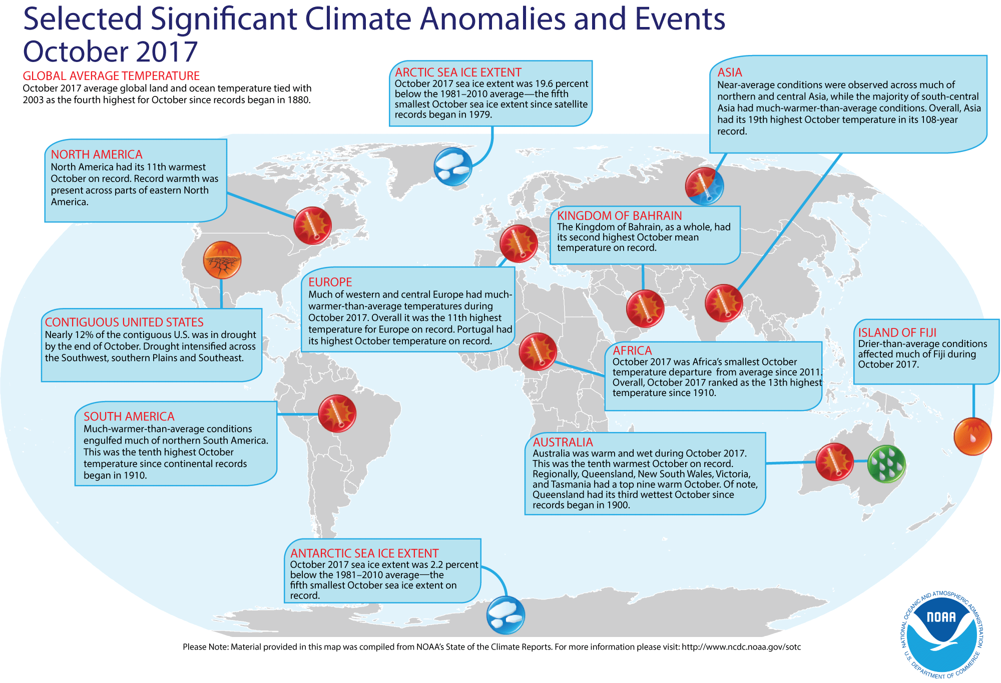
- Review of October 2017 global temperatures and sea ice cover -- Preliminary data analyzed by scientists at NOAA's National Centers for Environmental Information (NCEI) indicated that the global combined land and ocean average surface temperature for the October 2017 was 1.31 Fahrenheit degrees above the 20th century average (1901-2000) for the month. Therefore, last month's global combined temperature tied the temperature for October 2003 for being the fourth highest October temperature since global temperature records began in 1880. When considered separately, the monthly average temperature over the global oceans for October 2017 was 1.13 Fahrenheit degrees above average, the fourth highest October ocean temperature in 138 years of record. The monthly average temperature of the land surface for this recently concluded month was 1.78 Fahrenheit degrees above average, which represented the eleventh highest October land surface temperature on record.
When considering the combined land-ocean global temperature for the year to date (January-October 2017), this temperature was the third highest global temperature for the first ten months of any year since 1880. [NOAA/NCEI State of the Climate]
A global map of Selected Significant Climate Anomalies and Events for October 2017 is available from NCEI.
According to satellite data collected by National Snow and Ice Data Center, the sea ice over the Arctic Ocean during October 2017 was the fifth smallest areal extent for any October since satellite-derived ice records began in 1979. The sea ice around Antarctica also was the fifth smallest October ice extent in the last 39 years. [NOAA/NCEI Global Snow & Ice]
- An All-Hazards Monitor -- This Web portal provides the user information from NOAA's National Weather Service, FAA and FEMA on
current environmental events that may pose as hazards such as tropical
weather, fire weather, marine weather, severe weather, drought and
floods. [NOAA/NWS Daily Briefing]
- Earthweek --
Diary of the Planet [earthweek.com].
Concept of the Week: Climate Feedback
Processes
Earth's climate system includes many interacting variables.
Some variables are external to the Earth-atmosphere system and some are
internal. External variables include solar energy output and Earth-sun
geometry (i.e., the Milankovitch cycles). Internal variables include
properties of the Earth's surface (e.g., albedo, moisture), the
concentration of key atmospheric components (e.g., greenhouse gases,
sulfurous aerosols), and cloud cover and thickness.
An important consideration in understanding how Earth's
climate system responds to some perturbation is feedback. Feedback is defined as a sequence of interactions among variables in a
system that determines how the system responds to some initial
perturbation in one or more of the variables. Variables in Earth's
climate system may interact in such a way as to either amplify (positive
feedback) or lessen (negative feedback) a
change in climate. An example of positive feedback is the ice-albedo
effect described in Chapter 12 of the AMS Ocean Studies textbook.
Less ice cover in the Arctic greatly reduces the albedo of the Arctic
Ocean causing higher sea surface temperatures and accelerated melting
of the multiyear pack ice.
Consider an example of negative feedback. Increasing
concentrations of atmospheric carbon dioxide enhances the greenhouse
effect causing global warming. Global warming in turn raises sea
surface temperatures and increases the rate of evaporation. A more
humid atmosphere means more persistent and thicker cloud cover but
clouds have both a cooling and warming effect on the lower atmosphere.
The relatively high albedo of cloud tops causes cooling whereas
absorption and emission of infrared radiation by clouds causes warming
by contributing to the greenhouse effect. Satellite measurements and
numerical models indicate that cooling would dominate.
In general, negative feedback tends to dominate over positive
feedback in Earth's climate system, limiting the magnitude of climate
change. The great thermal inertia of the ocean is the principal reason
for dampening the planetary temperature response.
Historical Events:
- 27 November 1701...Anders Celsius, the astronomer who invented the Celsius thermometer scale, was born in Uppsala, Sweden. (National Weather Service files)
- 27 November 1703...The first Eddystone Lighthouse off the
coast of Devon, England (approximately 14 miles southwest of Plymouth)
was destroyed in the "Great Storm," and killed its builder Henry
Winstanley. This first light was in an octagonal wooden structure built
in 1698. The "Great Storm" is reported to have killed more than 8000
people. (Wikipedia) (Today in Science History)
- 27-28 November 1905...Heavy snow and wind blasted the
western Great Lakes with as much as seven inches of snow in
northwestern Wisconsin and sustained winds of 42 mph recorded at
Duluth, MN for 29 straight hours and 65 mph winds for 13 continuous
hours. Severe drifting resulted. Eighteen ships were destroyed or
disabled on Lake Superior. The ship Mataafa was
grounded and broke in two in Duluth harbor. Nine of the fifteen crew of
the Mataafa froze to death despite running aground
within 100 yards of the shore. (Accord Weather Guide Calendar)
- 28 November 1520...Portuguese navigator Ferdinand Magellan
reached the Pacific Ocean after passing through the treacherous South
American strait that now bears his name in a 38-day passage. He was the
first European to sail into the Pacific Ocean from the Atlantic to the
east. (The History Channel)
- 28 November 1960...A severe storm produced waves 20 to 40
feet high on Lake Superior. Duluth, MN was buried under a foot of snow,
and clocked wind gusts to 73 mph. The northern shore of Lake Superior
was flooded, and property along the shore was battered. Thousands of
cords of pulpwood were washed into Lake Superior, and up to three feet
of water flooded the main street of Grand Marais. Thunder accompanied
the "nor'easter". (David Ludlum) (The Weather Channel)
- 30 November 1925...An extremely rare late November hurricane began to affect the west coast of Florida as it strengthened during the day. The storm made landfall very early on 1 December south of Tampa Bay, weakened to a tropical storm as it crossed central Florida, and exited around St. Augustine. The storm regained Hurricane strength off Jacksonville late on the 1st. Heavy rain continued over northeast Florida on the 2nd. Gale force winds were reported from the Keys to Jacksonville and over 50 people lost their lives, mostly on ships at sea. Damage along the coast south of Jacksonville was heavy and excessive rain and wind seriously damaged citrus and truck crops. (National Weather Service files)
- 1 December 1969...Ocean swells generated by a storm more
than 1000 miles to the north-northwest of the French Frigate Shoals
produced 50-foot high surf along the outer shoals of Tern Island,
submerging the 300-foot wide island under two to three feet of water.
The 19-member Coast Guard contingent was evacuated, but considerable
damage was done to buildings. (Accord Weather Guide Calendar)
- 1 December 1990...Workers from the United Kingdom and
France on the Channel Tunnel construction project met approximately 120
feet beneath the English Channel seabed, to establish the first ground
connection between the British Isles and mainland Europe since the last
Ice Age. (Wikipedia)
- 2 December 1755...The second Eddystone Lighthouse near
Plymouth, England was destroyed by fire. This light had replaced an
earlier light that had been destroyed in the "Great 1703 Storm." The
current structure is the fourth light to be constructed at that site.
(Wikipedia)
- 3 December 1905...On this date the U.S. Weather Bureau received its first weather report from a ship at sea via wireless. (National Weather Service files)
- 3 December 1952...A remarkable display of sea smoke was
seen in Hong Kong harbor. The sea-smoke, induced by a strong surge of
arctic air, poured from the water of Kowloon Bay from 8 AM to 9:30 AM.
The air temperature near the sea wall was 44 degrees F. (Accord Weather
Guide Calendar)
- 3 December 1992...The Greek oil tanker Aegean
Sea carrying 80,000 tons of crude oil ran aground in a storm while
approaching La Coruña, Spain, spilling much of its cargo. (Wikipedia)
- 3
December 1999...After rowing for 81 days and 2962 miles, Tori Murden
became the first woman to cross the Atlantic Ocean by rowboat alone
when she reached Guadeloupe after departing from the Canary Islands.
(Wikipedia)
Return to RealTime Ocean Portal
Prepared by DS Ocean Central Staff and Edward J. Hopkins,
Ph.D.,
email hopkins@aos.wisc.edu
© Copyright, 2017, The American Meteorological Society.